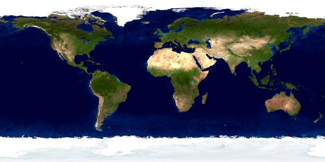
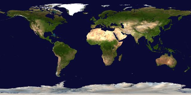
Land Surface, Ocean Colour, and Sea Ice
When the NASA Visible Earth Terra/MODIS image is selected, map and large-scale views are generated from a composite database specially prepared for Earth and Moon Viewer from the following two NASA images:
Land Surface, Ocean Colour, and Sea Ice
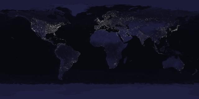
Land, Ocean Colour, Sea Ice, City Lights
The original NASA images are 8192×4096 pixels, corresponding to a resolution of about 5 kilometres per pixel at the equator. (The images shown above have been reduced in size to fit on this Web page; if you want to process these images for a project of your own, please start with the full-resolution images, which may be downloaded from the NASA Earth Observatory site.)
These images, used for the sunlit and night sides of the Earth, respectively, provide natural-looking pictures (if a cloudless Earth can be considered in any way “natural”), and are suitable for views ranging from a full hemisphere down to views from satellites in low Earth orbit. If you attempt to zoom in closer, however, the limitations of the 5 km per pixel resolution of the database begin to become apparent. The picture at left below is the result of zooming in on the Tokyo Bay area, displaying an area subtending 4 degrees of longitude, roughly equivalent to the view from an altitude of about 10 kilometres.
| Tokyo Area: 4° Map View | |
|---|---|
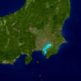 |
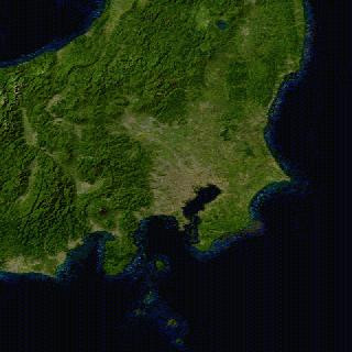 |
| 5 km/pixel | 1 km/pixel |
At this scale, the individual pixels in the 5 km/pixel image become apparent and the lack of detail is obvious. To improve image quality on such close-up views, Earth and Moon Viewer automatically switches to an alternative image database with 1 km/pixel resolution, also based on data from the NASA Terra/MODIS instrument. The above right image demonstrates the improvement from using this higher-resolution imagery. The 1 km/pixel image is not simply a higher resolution version of the 5 km/pixel database, however. While the 5 km/pixel image approximates the colour of the ocean and includes sea ice in the polar regions, the 1 km/pixel image shows the oceans with uniform colour except in shallow regions and shows ice only on land masses—the north polar region, consequently, appears ice-free in this image. There is no 1 km/pixel image which includes sea ice and ocean colours, so when you zoom in sufficiently to require the high resolution database, you'll see the change in the resulting images. The image below shows a map view of the 1 km/pixel database.
Land Surface, Shallow Water, and Shaded Topography
 In addition, there is no 1 km/pixel image of lights at night, so
if you zoom into a region in darkness or twilight, you'll
continue to see night lights at 5 km/pixel resolution, which may
look pretty awful. The picture at the right shows a view of
twilight falling in western Switzerland from an altitude of 12
km. Lake Geneva is near the centre of the image, and the yellow
splotches surrounding it are the lights of the cities along its
shore. The limited resolution of the city lights compared to
the terrain is obvious here. When making close-up zoom images
of areas in darkness, you may wish to check the “No
night” box to disable display of the limited resolution
city lights.
In addition, there is no 1 km/pixel image of lights at night, so
if you zoom into a region in darkness or twilight, you'll
continue to see night lights at 5 km/pixel resolution, which may
look pretty awful. The picture at the right shows a view of
twilight falling in western Switzerland from an altitude of 12
km. Lake Geneva is near the centre of the image, and the yellow
splotches surrounding it are the lights of the cities along its
shore. The limited resolution of the city lights compared to
the terrain is obvious here. When making close-up zoom images
of areas in darkness, you may wish to check the “No
night” box to disable display of the limited resolution
city lights.
Return to Earth and Moon Viewer