« March 29, 2018 | Main | April 12, 2018 »
Tuesday, April 3, 2018
Earth and Moon Viewer: New Topographic Maps
Since 1996, Earth and Moon Viewer has offered a topographic map of the Earth as one of the image databases which may be displayed. This map was derived from the NOAA/NCEI ETOPO2 topography database. Although the original data set contained samples with a spatial resolution of two arc seconds (two nautical miles per pixel, or a total image size of 10800×5400 pixels), main memory and disc size constraints of the era required reducing the resolution of the image within Earth and Moon Viewer to 1440×720 pixels. This was sufficient for renderings at the hemisphere or continental scale, but if you zoomed in closer, the results were disappointing. For example, here is a view of Spain, Portugal, France, and North Africa viewed from 207 kilometres above the centre of the Iberian peninsula.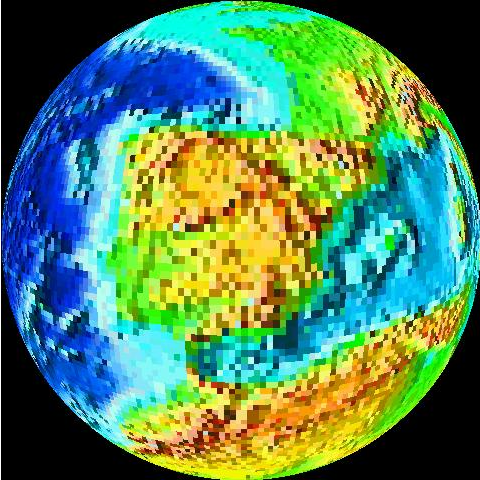 More than twenty years later, in the age of “extravagant computing”, and on the threshold of the Roaring Twenties, we can do much better than this. I have re-processed the raw ETOPO2 data set to preserve its full resolution, and with pixels which can represent 65,536 unique colours instead of the 256 used before. Here is the same image rendered from the new ETOPO2 data.
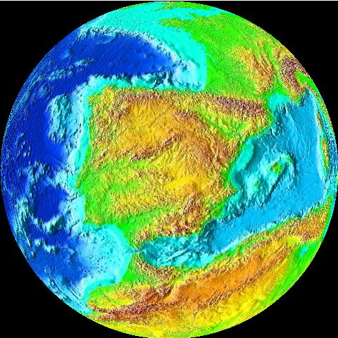 The colours in this rendering are somewhat garish and nonetheless do not necessarily show fine detail well. Images with this database tend to look their best at either very large scale or zoomed in to near the resolution limits of the database.
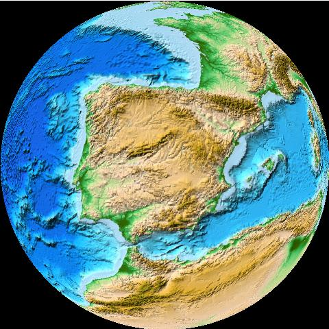
In 2009, the ETOPO1 data set was released, replacing ETOPO2 for most applications. The data have twice the spatial resolution: 1 arc minute, corresponding to one nautical mile per pixel or a total image size of 21600×10800 pixels. The permanent ice sheets of Antarctica, Greenland, and some Arctic islands are included in the elevation data. Earth and Moon Viewer now provides access to a rendering of this data set, which may be selected as “NOAA/NCEI ETOPO1 Global Relief” on any page which allows choosing an Earth imagery source. The full resolution of the database is available for close-ups. Here is the same view as that above rendered with the ETOPO1 data set.
The colours in this rendering are somewhat garish and nonetheless do not necessarily show fine detail well. Images with this database tend to look their best at either very large scale or zoomed in to near the resolution limits of the database.
In 2009, the ETOPO1 data set was released, replacing ETOPO2 for most applications. The data have twice the spatial resolution: 1 arc minute, corresponding to one nautical mile per pixel or a total image size of 21600×10800 pixels. The permanent ice sheets of Antarctica, Greenland, and some Arctic islands are included in the elevation data. Earth and Moon Viewer now provides access to a rendering of this data set, which may be selected as “NOAA/NCEI ETOPO1 Global Relief” on any page which allows choosing an Earth imagery source. The full resolution of the database is available for close-ups. Here is the same view as that above rendered with the ETOPO1 data set.
 The original low-resolution ETOPO2 data set remains available for compatibility with saved URLs which reference it, but is not directly requested by Earth and Moon Viewer's query pages.
Posted at
21:32
![]()